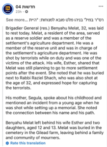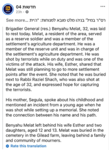
In the wake of the events in the village of Tel, southwest of Nablus, that resulted in the martyrdom of four Palestinians and killing of two Israeli settlers, Israeli media outlets, including Ynet and Channel 04 alongside Israeli Prime Minister Benjamin Netanyahu, promoted a narrative claiming that the incident was a “terrorist attack” targeting settlers who were “hiking.”
Yair Golan, leader of the Israeli Democrats party, also adopted this narrative. In a post on X, formerly Twitter, he described the incident as a “terrorist attack” and called for “striking terrorism with a harsh military force, with determination and without compromise,” adding that this must be accompanied by a “strategic initiative targeting the infrastructure of terrorism and its supporters to prevent its growth.”
The Israeli occupation army spokesperson, Captain Ella, attacked martyr Hussein, claiming he had carried out an armed operation, stating that: “He is not a mujahid sheikh as some attempt to portray him… but an atheist terrorist,” adding, “Islam is innocent of him and his actions.”
The Claim: A Palestinian terrorist attack in the village of Tel results in the death of two occupation soldiers while providing protection for a group of settlers on a hike.
Kashif verified this claim by analyzing circulated photos and video footage, conducting geographical measurements using Google Earth, contacting the Tel Village Council, and comparing the various accounts against visual and field evidence.
First: Where Did the confrintation Take Place?
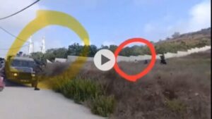
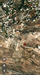
Kashif’s team relied on an image showing the mosque of Tel village in the background, matching the visible landmarks with satellite imagery to determine the exact location.
Measurements revealed that:
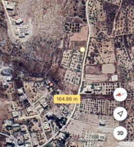
* The site of the confrontation is 164 meters from the Tel village mosque.
* It is located within the structural master plan of the village.
* It is only 90.68 meters away from the nearest Palestinian home.
* It is approximately 400 meters away from the bypass road leading to the “Yitzhar” settlement.
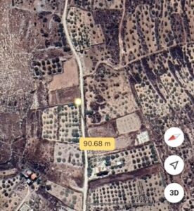
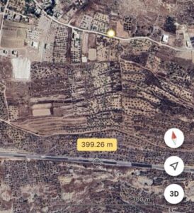
These data indicate that the group of settlers reached the inside of the village’s land from the bypass road, rather than being in an open area or a designated hiking trail.
The Village Council also confirmed to Kashif that the land where the clash took place is owned by Palestinian citizen Abdul Rahman Radi Ishtayeh and lies within the territorial boundaries of Tel.
Second: What Does the Village Council Say?
Kashif collected details of the events from the Village Council, which indicated that the assault began on the morning of Friday, 24 July 2026, in the eastern area of the village. Settlers attacked the home of Palestinian citizen Naseem Al-Saifi and the surrounding farm while his wife and children were inside.
According to the council, several villagers rushed to defend the home, including martyr Farouq Hussein Ali Ramadan, who is related to the homeowners. The initial clashes ended with the settlers withdrawing from the eastern sector.
The council added that the settlers later moved to the southern area of the village, specifically to the land of Abdul Rahman Ishtayeh, where clashes erupted anew.
Farouq Hussein was attempting to prevent direct clash between the two sides before events escalated with the arrival of Israeli occupation forces. According to the council, the forces provided protection to the settlers while opening fire, which led to the injury of Palestinian citizen Urwa Hussein Ali Ramadan, who was later arrested from the hospital along with his brother.
The council stated that a physical altercation ensued, during which Farouq Hussein managed to disarm one of the settlers, taking his rifle and firing several warning shots into the air. The situation subsequently escalated into a gunfire exchange that led to the martyrdom of four Palestinians and the death of two settlers.
Third: What Did the Photos and Videos Show?
Kashif cross-referenced the Village Council’s account with the circulated photos and videos, finding a clear match in the sequence of events.
Visual analysis revealed:
* The first image documents martyr Farouq Hussein standing unarmed.
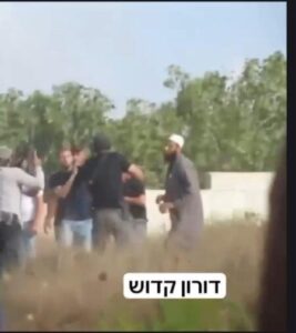
* The second image shows him being attacked by an armed settler.
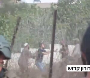
* The third image documents Farouq, along with another young man, attempting to
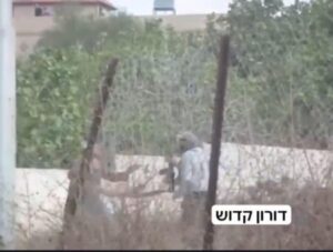
overpower the settler and gain control of his weapon.
* The fourth image shows Farouq after taking control of the rifle and firing it.
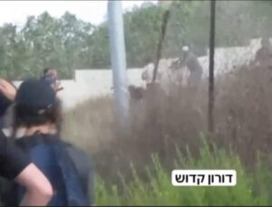
The footage does not show Farouq carrying any weapon prior to the altercation with the settler.
Fourth: What Do Google Earth Measurements Reveal?
Kashif utilized Google Earth’s measurement tools to determine the nature of the location where the events occurred.
The results showed that the site of the clash:
* Lies within the urban boundary of Tel village.
* Is less than 100 meters away from the nearest Palestinian house.
* Is situated on private land owned by a Palestinian citizen.
* Does not align with the description of a “hiking area” or a designated walking path.
Furthermore, the distance between the bypass road and the site of the clash indicates that the settlers penetrated nearly 400 meters inside village lands before the confrontations took place.
Fifth: Israeli Divergence Over the “Hiking” Narrative
The events in Tel revealed a rift in stances within Israel between those who adopted the official narrative framing the event as a “terrorist attack” and Israeli figures who blamed the government and settlers for the escalation, describing the event as “Jewish terrorism.”
Former Israeli Defense Minister Moshe Yaloun rejected the official narrative, stating:
This is not a terrorist attack; it is friction ignited by Israelis at the Tel village mosque and by entering the village… This is a clash, but it does not happen in a vacuum.”
He added that what happened falls under a “systematic policy” led by the Israeli government, saying:
“There is a systematic policy here, shaped by ministers in the Israeli government who supply these people (settlers) in various areas with tools, such as vehicles and other means, to displace more than 100 pastoral communities in the West Bank.”
Yaloun described the ongoing events as “Jewish terrorism,” adding:
“This is a clash, but it is Jewish terrorism that has killed more than 30 Palestinians… After eliminating the pastoral communities, they are now heading toward Palestinian villages to displace their people from their lands; therefore, there is a systematic policy here.”
In the same context, former Israeli football player and TV analyst Eyal Berkovic criticized the presence of settlers in Tel, questioning:
“I don’t understand what they were doing there in the first place; why do they go there?”
He added that sending settlers into areas prone to security clashes places a burden on the military, asking:
“Why do we need to send soldiers to protect people who go into dangerous places?”
These statements demonstrate an internal Israeli dispute regarding the classification of the events in Tel. Prominent Israeli figures held the government and settlers responsible for the escalation, contradicting the official narrative that presented the events as a “terrorist attack” targeting hikers.
Sixth: Escalation of Settler Attacks in 2026
The events in Tel occurred against the backdrop of an unprecedented surge in settler attacks across the West Bank.
According to a report published by the Wall and Settlement Resistance Commission on 6 July 2026, the first half of the year recorded:
* 11,047 violations committed by occupation forces and settlers.
* 3,488 direct attacks carried out by settlers.
* 17 Palestinian martyrs killed as a result of settler attacks.
* 900 attacks recorded in the Nablus Governorate, marking the highest rate in the West Bank.
The report also documented:
* The establishment of 42 new settlement outposts.
* The confiscation of 4,379 dunams of Palestinian land.
* Approvals for the construction of 34 new settlements.
* The demolition of 740 Palestinian structures.
* The uprooting or damaging of over 45,000 trees, including more than 26,000 olive trees.
Investigation Conclusion
The investigation conducted by Kashif, based on photo and video analysis, Google Earth measurements, geolocation mapping, and direct contact with the Tel Village Council—demonstrates that the clash took place inside the territory of Tel village and in direct proximity to Palestinian homes, not in a remote area or on a designated hiking trail as claimed by Israeli media.
Visual evidence further confirms that martyr Farouq Hussein was unarmed at the beginning of the confrontation and that his acquisition of the settler’s weapon occurred during the physical altercation, aligning with the Palestinian narrative documented by the Village Council.
Accordingly, the claim that the incident was a “terrorist attack targeting settlers who were hiking” is unsupported by geographical data and field evidence. The Israeli narrative is therefore misleading to both local and international public opinion.